How can the quality of forage and resource consumption in agriculture be monitored? The answer comes from space: Using hyperspectral satellite data, OHB System AG aims to demonstrate, through the HyLAP project (Hyperspectral Products for Agricultural Practice), how grassland can be used optimally. The data provides insights into plant characteristics that are not visible to the naked eye—and opens up new avenues for more precise and resource-efficient agriculture.
The focus of the study is the German hyperspectral satellite EnMAP (Environmental Mapping & Analysis Program), which has been in orbit for three years and, with its 242 spectral bands, captures light ranging from the visible spectrum to the short-wave infrared. Developed and built by OHB on behalf of the German Space Agency at the German Aerospace Center (DLR), EnMAP provides scientific data of unprecedented quality. Its data is also intended to be made available for use outside of research—for example, for farmers who wish to manage their fields more effectively.
“With HyLAP, we want to demonstrate how hyperspectral data can be effectively applied in practice—including in combination with traditional methods such as field inspections,” explains Dr. Anita Bayer, head of the “Earth Observation Applications” team at OHB. Together with users across the agricultural value chain, including state agencies, agricultural insurers, and private-sector companies, her team is investigating, among other things, grassland areas and whether improved monitoring can help increase the quality and quantity of forage.
The right time to harvest determines the quality of the forage
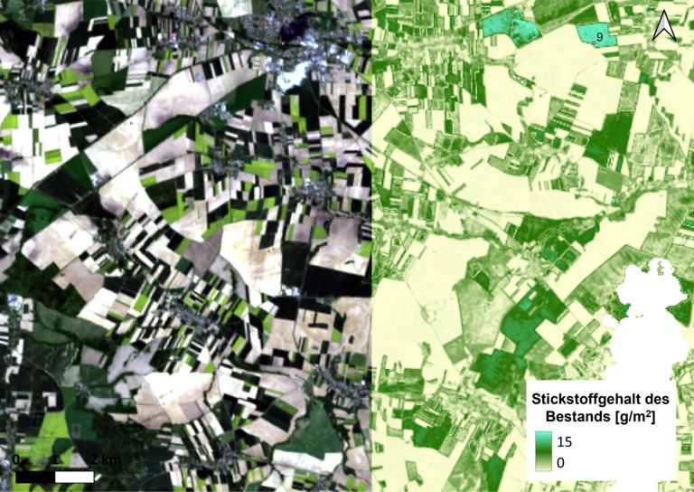
Pastures are mowed up to six times a year—but exactly when this happens is usually determined by the farmer’s experience and the weather. Laboratory analyses are rare, and guidelines from state agencies are based on spot samples. Hyperspectral satellite data, on the other hand, can provide comprehensive information about the nitrogen content of plants—and thus about their protein content, an important indicator of forage quality. By regularly collecting this data, farmers could make targeted decisions about when and where to mow, depending on the animals’ needs: dairy cows require protein-rich feed, while young animals can get by with less.
Focus on Sugar Beets – Together with KWS
In addition to grassland, the HyLAP team, in collaboration with the seed company KWS, is also focusing on sugar beets. Here, they are leveraging a unique feature of hyperspectral sensors: unlike other satellite-based sensors, they capture a continuous spectrum, which is crucial for determining plant and crop characteristics. This opens up new possibilities for precise crop monitoring and sustainable farming. The collaboration with KWS is already underway in the ESA projectAgriCEM, which is preparing the use of data from future satellite missions (in particular the Copernicus missions CHIME and LSTM) in agricultural practice.
HyLAP, on the other hand, focuses on using the existing EnMAP data for demonstration purposes. The project launched in early 2025, will run for 16 months, and is co-funded by the German Space Agency within the DLR.
About EnMAP, CHIME, and LSTM
EnMAP(Environmental Mapping and Analysis Programme): German hyperspectral satellite, imaging range from 420 to 2450 nm (blue visible light to short-wave infrared) across 242 channels, minimum revisit time of 4 days, spatial resolution of 30 m, launch in April 2022, tasking mission.
CHIME (Copernicus Hyperspectral Imaging Mission for the Environment): 2 Hyperspektralsatelliten mit 200 Spektralkanälen im Bereich vom sichtbaren Licht bis zum Kurzwelleninfrarot (400-2500 nm), Wiederbesuchszeit 12,5 Tage, räumliche Auflösung 30 m, Start erster Satellit: 2029.
LSTM (Land Surface Temperature Monitoring): 2 Satelliten zur präzisen Messung der Landoberflächentemperatur, Wiederbesuchszeit 1-3 Tage, räumliche Auflösung <50 m, Start erster Satellit: 2029.